
Izégouandane Gr
Type Locality and Naming
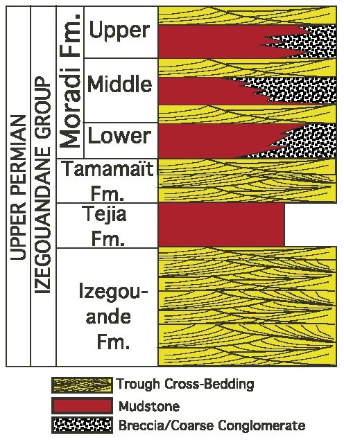
Tim Mersoï Sub-basin. Joulia (1953) emend. Bigotte & Obelianne (1968). It corresponds to two sedimentary mega-sequences, each divided into formations (the Lower Subgroup: Izégouande Fm and Téjia Fm, and the Upper Subgroup: Tamamaït Fm and Moradi Fm) (Fig. 2).
References: Joulia, 1953; Abdoul Aziz, 1968; Bigotte & Obelianne, 1968; Valsardieu, 1971; Ministère des Mines et de l’Hydraulique, Direction des Mines et de la Géologie, 1977; Fabre et al., 1983; de Rouvre, 1985, 1988; Kogbe, 1991; Sidor et al., 2003; Fabre, 2005; Tabor et al., 2011; Billon et al., 2016.
Synonym: Izegouandane Gr. Série d’Izégouandane. [NOTE: Izégouande is the proper spelling of the formation, while Izégouandane is the appropriate spelling of the Group.]
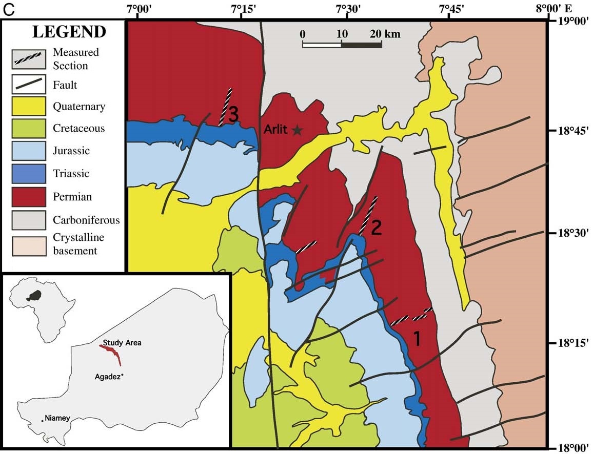
[Figure 1. Geological map of part of the Tim Mersoï Sub-Basin outlining the Permian Izégouandane Gr (Modified from Tabor et al., 2011) The three sections can be seen in Fig. 7-102.]
Lithology and Thickness
According to Valsardieu (1971) (see each formation of the Group for more details):
- The Izégouande Fm (the lowest formation) comprises sandstone layers arranged in channels cutting one another. The most frequent facies is a coarse arkosic sandstone with a micro-conglomeratic appearance. The matrix is strewn with pebbles, faceted quartz, argillite nodules, basement pebbles (quartzite, rhyolite), silicified wood debris (Dadoxylon rollei). The maximum thickness in the Arlit region (110-130 m) decreases (50 m) towards the east and the West. The paleocurrents are directed north.
- The red-brown argillites and marls of Téjia Fm, with fine sandstone lenses, 15 to 20 m thick on average, correspond to a lacustrine regime setting. They are often eroded by the sandstones of the Tamamaït Fm above.
- The Tamamaït Fm displays medium to fine, feldspathic sandstone, with argillite pebbles, carbonate cement, and oblique stratification, alternating with marls and argillites for approx. 40 m. (in drilling). The current directions are variable.
- The ferruginous clays and silty marls of the Moradi Fm are cut by a more resistant horizon were lenses of sandstone and conglomerate “float” in the clays. The pebbles are of autochthonous origin (sandstone, argillite, limestone, silicified wood, vertebrate bones) or allochthonous (quartz, feldspar). This formation, deposited in a lake environment, is rich in acidic volcanic debris, analcime and carbonates. It has yielded numerous mammalian reptiles, Captorhinomorphs and silicified woods that date to the Upper Permian.
Thickness: 300 m (Lower = 120 m; Upper = 180 m).
[Figure 2. Generalized stratigraphy of the Permian Izégouandane Group in the Tim Mersoï Sub-Basin (Source: Modified from Tabor et al., 2011).]
Relationships and Distribution
Lower contact
Rests in discordance on the Tagora Gr in the north and Terada GrGroup in the south.
Upper contact
The transgressively overlain by the Teloua Fm (Teloua 1 Mbr) of Triassic
Regional extent
Tim Mersoï Sub-basin.
GeoJSON
Fossils
Silicified wood debris (Dadoxylon rollei), vertebrate bones, mammalian reptiles, Captorhinomorphs, amphibians, Therapsids
Age
Depositional setting
Continental. The Izégouandane Gr (with the Agadez Gr of the Triassic and Jurassic Periods) corresponds to red detrital deposits. It is derived from alteration products generated by a hot climate with seasonal variations (wet and dry) and is attributed to a fluvial and lacustrine environment. Volcanic inflows have been recorded in this group in the form of rhyolitic pebbles and ash.
Additional Information